

|
|
TOWNSHIP ORGANIZATION
At the meeting of the County Commissioners' Court, July 5, 1842, it was resolved to organize the county into townships, which should have their regular township officers and town government. The precincts were accordingly changed into townships, without altering the boundaries.
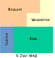
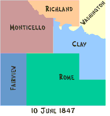
Rome was organized as a township July 5, 1842 with the same boundaries as Walnut Precinct, given above, the first township election to be held at the residence of N. B. Seeley.
Fairview was organized as a township July 5, 1842, with the same boundaries as Buffalo Fork Precinct, given above.
Washington was organized as a township July 5, 1842, with the same boundaries as Farm Creek Precinct, given above.
Richland was organized as a township July 5, 1842, with the same boundaries as Bowen Prairie Precinct, given above.
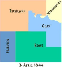
Clay was organized as a township April 3, 1844, including what is now known as Wyoming, that part of the present township of Clay which is south of the Maquoketa River, all of Scotch Grove Township south of the river, and a strip about one mile in width upon the eastern border of Wayne Township, extending north, through Monticello, until it touched the river. The first election was held at the house of John Southerland.
Monticello was organized as a township June 10, 1847, from Richland Township, and included all of that town south of the Maquoketa River, being most of the territory now occupied by Monticello, Wayne, Cass and Castle Grove. (Note: Lovell township was organized as a separate township about January, 1898 with the same boundaries as Monticello township, the latter being included within Lovell township, the corporation of Monticello being declared a separate township and called Monticello township.)
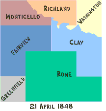
Greenfield was organized as a township with its present boundaries, being separated from Fairview, and corresponding to Congressional Township 83, Range 4. The townships now known as Cass and Wayne were separated from Monticello and attached to Fairview April 21, 1848.
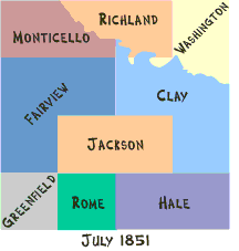
Hale was organized as a township in July, 1851, and included the present towns of Hale and Oxford, which were on that date separated from Rome. The first township election was held at the house of Joseph Bumgarner.
Jackson was organized as a township in July, 1851, and included the present towns of Madison and Jackson, which were on that date separated from Rome. The first township election was held at the house of Chas. Beam.
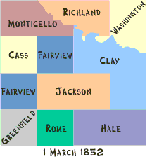
Cass was separated from Fairfield(sic) and organized as a township, with its present boundaries, March 1, 1852. The first election was at the house of W. J. Beaks.
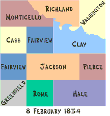
Wyoming was separated from Clay Township February 8, 1854, and organized, with its present boundaries, under the name of Pierce Township, which was, a couple of years later, changed to Wyoming. The first election was at the house of William Stuart. (Note: Pierce was changed to Wyoming in 1857.)
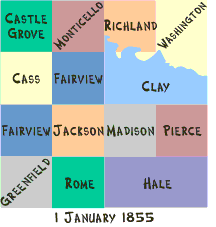
Castle Grove was separated from Monticello and organized, with its present boundaries, January 1, 1855. At the same date, Monticello Township was expanded across the river to the northern boundary of the county, corresponding to its present boundary, and including what had formerly belonged to Richland Township.
Madison Township was organized, with its present boundaries, Jan. 1, 1855.
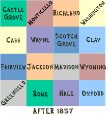
Scotch Grove was separated from Clay and organized, with its present boundaries, in February, 1855. The first election was held at a schoolhouse.
Oxford was separated from Hale Township and organized, with its present boundaries, in March, 1855. The first election was at the house of John Bryan.
Wayne was set off from Fairview Township and organized, with its present boundaries, March 5, 1856. The first election was at the house of O. G. Serivens.
It will be observed that the last township was not formed until some sixteen years after the organization of the county, and that certain districts belonged at different periods, to quite a number of different towns. Wayne Township, for instance, had belonged to Richland, Monticello and Fairview previous to its organization as an independent town. Each township now corresponds to the Congressional numbering, rendering the political geography of the county as simple as a chessboard.
|
|
|