| NAME | LOCATION |
| Argand | A post office from 1880 to 1899, in section 4, Castle Grove Twp. |
| Big Woods | Listed in the U.S. Official Register of 1847 as a post office in Jones County, and mentioned in Corbitt's history, but not found on maps of that period. Thought to have been in Castle Grove Twp. |
| Bloomfield | Shown on maps of the early 1840s as a town laid out in the western part of Jones County on the north bank of the Wapsipinicon River. |
| Blue Cut | The name first given to the village and railroad station of Amber. The post office was Blue Cut from 1873 to 1878. |
| Bowen's Prairie | A village in the southwestern part of section 6, Richland Twp. Platted in 1853. Post office 1849 to 1902. |
| Cass Center | A post office from 1862 to 1865 in section 22, Cass Twp. |
| Castle Grove | A post office from 1851 to 1903, although not continuous, in Castle Grove Twp., and later in the southern part of section 3. |
| Clayford | A post office, 1861 to 1902, in the eastern part of section 7, Clay Twp. |
| Clay Mill | A village in the southern part of section 10, Clay Twp. Post office 1863 to 1902. |
| Condit | A post office from 1880 to 1882 in section 21 Cass Twp. |
| Dartmouth | The name first given to a town laid out in 1840 on a location which is now a portion of the present city of Anamosa. The plat was never recorded. |
| Downersville | A village in the western part of section 14, Castle Grove Twp. Post office from 1870 to 1872. |
| Duane | A post office from 1855 to 1861 in section 3, Cass Twp. |
| Edinburg | A town laid out in 1840 in the northern part of section 36, Wayne Twp. It was the first county seat of Jones County, 1840 to 1847. It never developed much. It had a post office from from 1840 to 1847, and the post office was revived in 1856, being a little north in section 25, and ran until 1873. |
| Elkford | The original survey of Rome Twp. was made by Deputy Surveyor W. Barrows from January 13 to February 3, 1838, and he reported finding the town of Elkford "laid out on the northeast and southeast quarter of section 11 and the northwest and southwest quarter of section 12," but that it had no improvements. That was about one mile northwest of the present town of Olin. |
| Farm Creek | Another name applied to the village of Clay Mill. |
| Fairview | A village laid out in 1841 near the center of section 20, Fairview Twp., about four miles southwest of Anamosa. Post office from 1843 to 1904. A few dwelling houses still remain. |
| Fuller's Mill | In the northeast part of Scotch Grove Twp., on the Maquoketa River. Post office from 1859 to 1869. |
| Garfield | The name of the post office at the town of Oxford Junction from 1880 to 1884. |
| Grove Creek | A post office from 1850 to 1880 on the north line of of section 4, Castle Grove Twp. |
| Hale City | The name by which the present village of Hale is shown on the maps of the early 1880s. |
| Hale Village | The name of the post office at the present village of Hale from 1872 to 1883. |
| Highland Grove | A post office in section 36, Fairview Twp., from 1852 to 1875. |
| Isabell | A village at the intersection of sections 13, 14, 23, and 24, Jackson Twp. Post office from 1857 to 1867. |
| Johnson | A village at the intersection of sections 23,24, 25,and 26, Scotch Grove Twp. A busy village in its day. Post office, 1853 to 1880. |
| Johnsontown | Name most often given to the town of Johnson. |
| Jonesville | The name given to the post office for a few months in 1840 that later became Edinburg. |
| Lexington | The original name of the southwestern portion of the present city of Anamosa, later called Dublin. |
| Madison | A village in sections 20 and 21, Madison Twp. Laid out in 1856. Post office, 1855 to 1873. |
| Marshfield | name first given to the post office at the town of Wyoming, which was in 1854. It changed to Wyoming in 1855. |
| Mineral Creek | A place in section 34, Scotch Grove Twp. According to maps of 1868. |
| Newport | A town platted in 1846, in the northern part of section 33, Jackson Twp., just north of the Wapsipinicon River. It was selected as the county seat in 1847, but never used. |
| Norwich | In section 32, Fairview Twp., as shown on maps of 1856. |
| Pamaho | A post office established in 1840, about one mile west of the village of Fairview, but a few months later it was removed to Fairview, but retained its name until 1843 when it was changed to Fairview. |
| Pierce | A post office from 1853 to 1857 in section 22, Wyoming Twp. |
| Richland | A town platted in 1856 in the southwest quarter of section 5, Richland Twp. A kind of suburb of Bowen's Prairie. |
| Rome | The original name of the present town of Olin. Rome was platted in 1842 and the name changed to Olin in 1868. |
| Spencerville | In section 3, Wyoming Twp. As shown on maps of 1881. |
| Strawberry Hill | Formerly an independent village adjacent to Anamosa on the east, but part of that city since 1901. |
| Temple Hill | A hamlet in the northern part of section 27, Washington Twp. It had a post office in 1857 to 1860, when it was discontinued but revived again and ran from 1884 to 1901. |
| Viroqua | The name of the present town of Morley from 1873 to 1886, the post office also having the same name. |
| Walnut Fork | A village that was slightly to the east of the present town of Olin and was platted in 1854. The post office was named Walnut Fork and ran from 1841 to 1872. |
| Zurich | A post office from 1860 to 1866 in section 4, Richland Twp. |


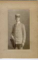 The handsome guy in this photo is my grandfather, Ernest B. Harrison, who was an Anamosa postman in the early part of the last century.